Route4Me Telematics And GPS Tracking Software Frequently Asked Questions
Easily integrate Route4Me’s Last Mile Route Optimization Software with Telematics and GPS Tracking vendors. After that, you can dispatch planned and scheduled routes to drivers and GPS vehicles for navigation and completion. Accordingly, you can then track drivers and vehicles on the interactive route map in real-time. Furthermore, you can track driver and vehicle performance, route progress, KPIs, idling time, fuel theft, route deviations, and more.
![]()
Yes, Route4Me’s Route Planner supports telematics integrations with almost all types of telematics tracking devices, allowing you to track drivers and team members by connecting to their GPS trackers, smartphones, smart handsets or headsets, and other devices. Moreover, your team can also use Route4Me’s iOS Route Planner and Android Route Planner apps that provide additional driver safety features and can be installed on any smartphone, Apple Watch, iPad, Android tablet, and other smart devices.
Telematics Tracking Devices Supported by Route4Me
Route4Me enables you to track drivers using multiple GPS tracking methods. For instance, you can integrate your Route4Me route optimization software with virtually any telematics solution on the market, including:
- ClearPathGPS
- CommandGPS
- EZ FLEET TRACKING
- Fleet Complete
- Geotab
- Verizon Connect
- Omni Telematics
- And a lot more!
So, with Route4Me, you are able to collect and analyze your telematics data and plan routes on the same platform. This helps you gain in-depth insights into your last mile operation. Plus, this way, you can also get a detailed overview of your team’s performance and fleet’s profitability.
Learn more about Route4Me’s telematics integrations.
![]()
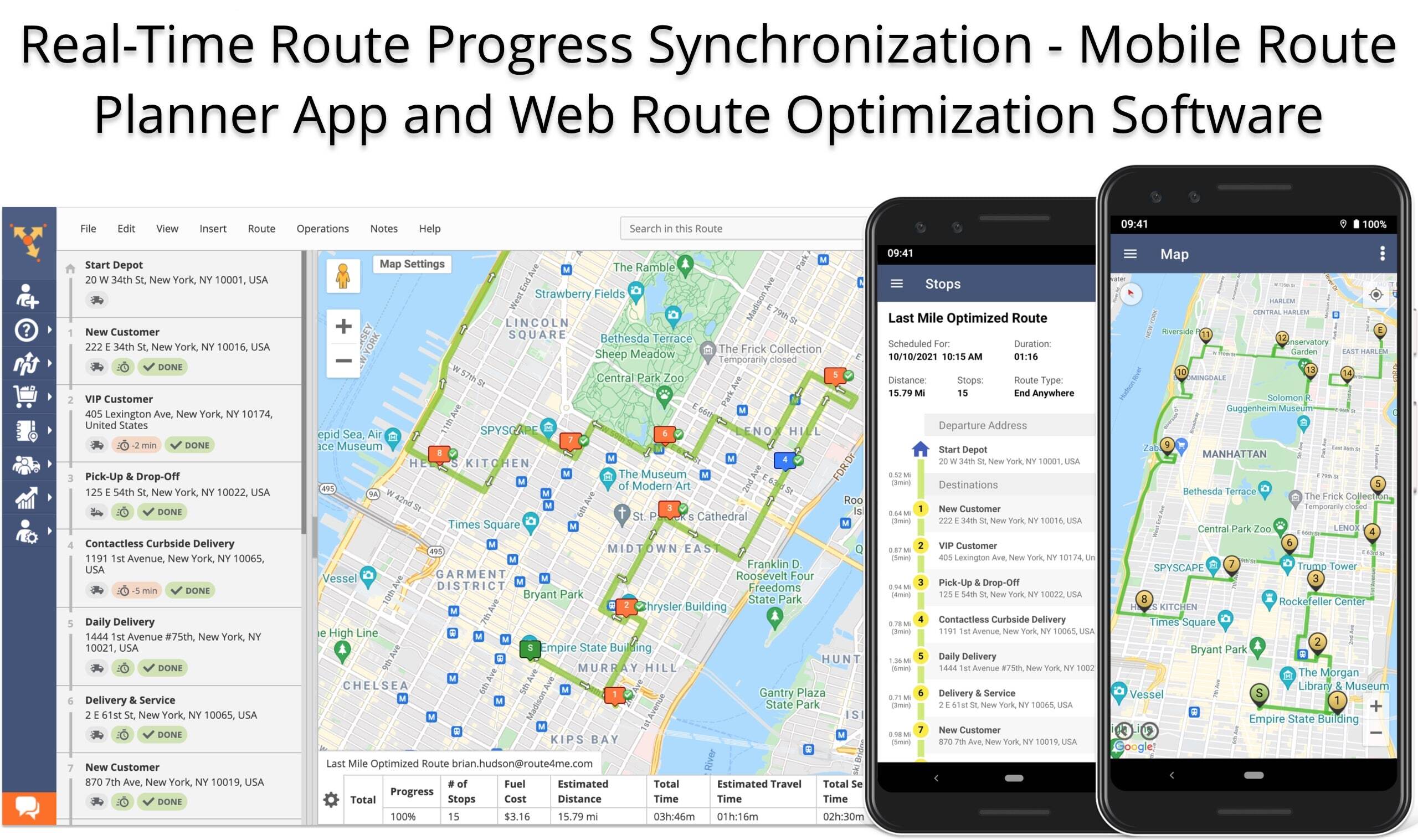
Driver Tracking With Route4Me’s Route Planner Apps
In addition to integrating with a wide range of telematics tracking devices and solutions, Route4Me enables you to track drivers with the help of its apps. Specifically, you can install the Android Route Planner and iOS Route Planner apps on your drivers’ mobile devices. Then, the apps will send a GPS signal to the web platform every few seconds so that you can track your drivers’ near real-time GPS locations.
Not only can you effortlessly leverage live driver tracking, but you can also watch your drivers’ GPS tracking history movie. Furthermore, Route4Me offers you the possibility to track multiple drivers simultaneously on the same map. And to further support your seamless collaboration and tracking efforts, our system enables you to use the Activity Feed as a live driver chat.
![]()
If you liked this request for proposal (RFP) post about the telematics tracking devices supported by Route4Me’s route planner, check out more Q&As!
Yes, Route4Me’s geofencing solutions allow you to set up a customizable virtual perimeter around any location on the map and automatically track when and where each geofence is entered or exited. Thus, when your vehicles enter or exit geofences, you will be able to see the exact GPS coordinates of each entry and departure point, as well as the precise time when each entrance or exit gate was crossed. For more convenience and productivity, you can also customize the shape, size, max entrance speed, and other parameters of your geofences.
Yes, Route4Me’s route optimization software enables last mile carriers and customers alike to track drivers using our easy-to-use delivery tracking tools. Specifically, Route4Me gives you the ability to leverage real-time driver tracking, GPS history tracking, and more! In addition to tracking drivers on a map, with Route4Me, you can also set up automatically-triggered geofences. By doing so, you and your customers get notified as soon as a driver enters or departs a geofenced area. Moreover, Route4Me’s iOS Route Planner and Android Route Planner apps also permit you to collect proof of service (POS) and proof of delivery (POD) data in the form of captured customers’ electronic signatures, photos, videos, and notes.
Delivery Tracking for Last Mile Carriers
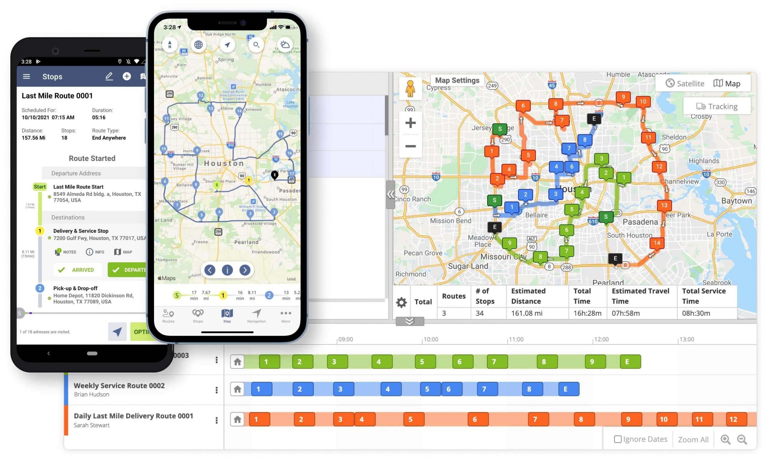
Route4Me’s Route Planner features multiple advanced driver tracking features that help last mile carriers to always be up to date with their drivers’ and fleet assets’ whereabouts. Specifically, when using Route4Me, you can view the real-time location of a particular driver on a map. Alternatively, Route4Me also enables you to view multiple drivers as they progress through their routes simultaneously on the same map.
Moreover, with Route4Me, you can access your drivers’ GPS tracking history in an animated video format. Other tracking tools you can employ in your day-to-day last mile operations include:
- Dynamic route deviation detection
- Planned vs. actual route metrics
- Automatically detected geofence activity vs. manually logged geofence activity data
- And more!
Further, as drivers progress on their routes, they can capture electronic signatures, images, videos, and audio recordings and attach the collected media files to route stops. Accordingly, these added notes can serve as electronic proof of delivery and proof of service. Further, the system automatically and instantly makes the attached ePOD files visible across the devices associated with your Route4Me account.
![]()
Driver Tracking for Customers
Furthermore, Route4Me’s route planning software offers multiple customer-facing delivery tracking tools. Namely, Route4Me features an Online Order Tracking Page for Customers. This Tracking Portal enables customers to track their orders on a map in near real-time.
Moreover, Route4Me gives you the ability to customize your Tracking Page with your company logo and custom icons for drivers and customers. Plus, with Route4Me’s E-Mail, SMS, and Voice Call Customer Notifications, you can send alerts to customers so they can be ready to pick up their packages upon drivers’ arrival.
![]()
If you liked this request for proposal (RFP) post about Route4Me’s delivery tracking features, check out more Q&As!
Yes, with Route4Me, you can track all your vehicles and team members on a single interactive map with the ability to move stops between displayed routes, insert new destinations into active routes, send chat messages to drivers, view driver details, check ETAs, and much more. Furthermore, you can also use the inbuilt Activity Stream for monitoring such performed actions as visited stops, added notes, attached signatures, canceled visits, and so on.
Yes, with Route4Me’s Activity Stream, you can view all activities that have been performed within each stop on your routes. For more convenience, you can also see the timestamps of each activity, the associated team member(s), attached data (i.e., photos, videos, signatures, etc.), and more. Moreover, with Route4Me’s Team Management tools, you can also customize the permissions of your team members, allowing them to see different types of information within your route stops.
Yes, you can use Route4Me’s Customer Alerting and Notifications module together with Route4Me’s geofencing technologies for automating the process of notifying your customers about the status of their orders. Route4Me allows you to set up custom-shaped geofences around all types of locations on the map and send or receive automated SMS, email, and voice call notifications when your geofences are triggered by your drivers. For more convenience and productivity, you can use placeholders that can automatically retrieve and attach the latitude and longitude coordinates of the location where the given geofences were entered or exited and triggered.
Yes, Route4Me provides integrations with almost all Telematics Vendors in the market, allowing you to import GPS data about your fleets and teams from any preferred telematics source. Once raw telematics data is imported into your Route4Me account, it is instantly processed and presented to you in the form of interactive dashboards and reports. Thus, Route4Me’s dashboards and reports can show you your organization’s near real-time costs, generated revenue, team performance, KPIs, route progress, and many other types of actionable intelligence.
Yes, Route4Me provides unlimited tracking data life, allowing you to view your tracking and tracing history for the entire period you have been collecting data.
Yes, moreover, Route4Me also allows you to adjust the GPS position refresh rate of your telematics vehicles and GPS devices. Thus, with Route4Me’s tracking technologies, the telematics position refresh rate of your assets can be manually adjusted to range from as frequently as 1 second to any other preferred interval. For more convenience, Route4Me supports almost all types of tracking and telematics devices that can have different update ranges. In addition to that, Route4Me’s iOS and Android mobile apps can update the GPS location of your assets as quickly as every second.
Route4Me’s route optimization software enables you to track drivers in real time as well as in retrospect. Namely, with Route4Me, you can always access your drivers’ Route4Me Tracking History. This way, your schedule will not be bound to your drivers’. So, Route4Me gives you the ability to track your drivers as they navigate planned routes on a map in near real-time, or you can simply watch the GPS history movie whenever you have the time – after the routes have been completed.
Learn more about Route4Me’s real-time driver tracking features.
How the Route4Me Tracking History Works
When the Route4Me Android Route Planner or iOS Route Planner app is installed on a drivers’ mobile device, it begins to emit a GPS tracking beacon. Then, the central Route4Me system registers the transmitted GPS signal every 60 seconds.
Moreover, even if internet connectivity is temporarily disabled, Route4Me will reconcile the entire GPS history when drivers are back online. Plus, if a driver opens a specific route when the device is in transit, the system will assign the location tracking history to the respective route so that a dispatcher, analyst, or manager can replay the device’s travel history.
Learn more about Route4Me’s:
![]()
What Data You Can View With Route4Me’s GPS Travel History
Furthermore, you can access the GPS Tracking History from any device associated with your organization’s Route4Me account.
Additionally, you can choose to watch the GPS history video for one driver at a time or for multiple drivers on the same map simultaneously. Plus, Route4Me’s GPS history feature gives you the ability to capture multiple route and driver behavior-related data. For instance, you can monitor aspects such as:
- Tracking trail
- Performed activities
- Unnecessary idling
- Unauthorized route detours
- And a lot more!
![]()
If you liked this request for proposal (RFP) post about how you can access your Route4Me tracking history, check out more Q&As!
Visit Route4Me's Marketplace to Check out Associated Modules:
- Operations
Custom Data Add-On
- Operations
Advanced Team Management Add-On
About author: Alex Yasko
Alex Yasko is the Go-to-Market Product Manager and Information Architecture Manager at Route4Me. With thousands of hours of experience, Alex specializes in breaking down complex last-mile optimization and routing scenarios into simple, actionable instructions, helping last-mile businesses streamline their operations effortlessly.