Google Maps Route Navigation – iPhone Route Planner App
With Route4Me’s iPhone Route Planner you can easily create, optimize, and navigate profitable last mile routes in real time. Our app integrates seamlessly with Waze, Apple Maps, CoPilot, and other navigation tools, delivering the best driving directions with a single tap. It also works with Google Maps, a free, user-friendly option for basic navigation, but lacking in the advanced features needed for complex, multi-stop commercial route planning. Learn when to use Google Maps on its own or alongside a more advanced route planner to get the best setup for your enterprise business.
Table of Contents
Send Route Destinations To Google Maps Route Planner
To navigate optimized routes using Google Maps, you need to send locations from the Route4Me app to Google Maps. To do this, you’ll need to configure Google Maps as your default route navigation map.
Tap “Settings” in the main menu. Then, from the Settings screen, tap “Navigation App” and select “Google Maps“.
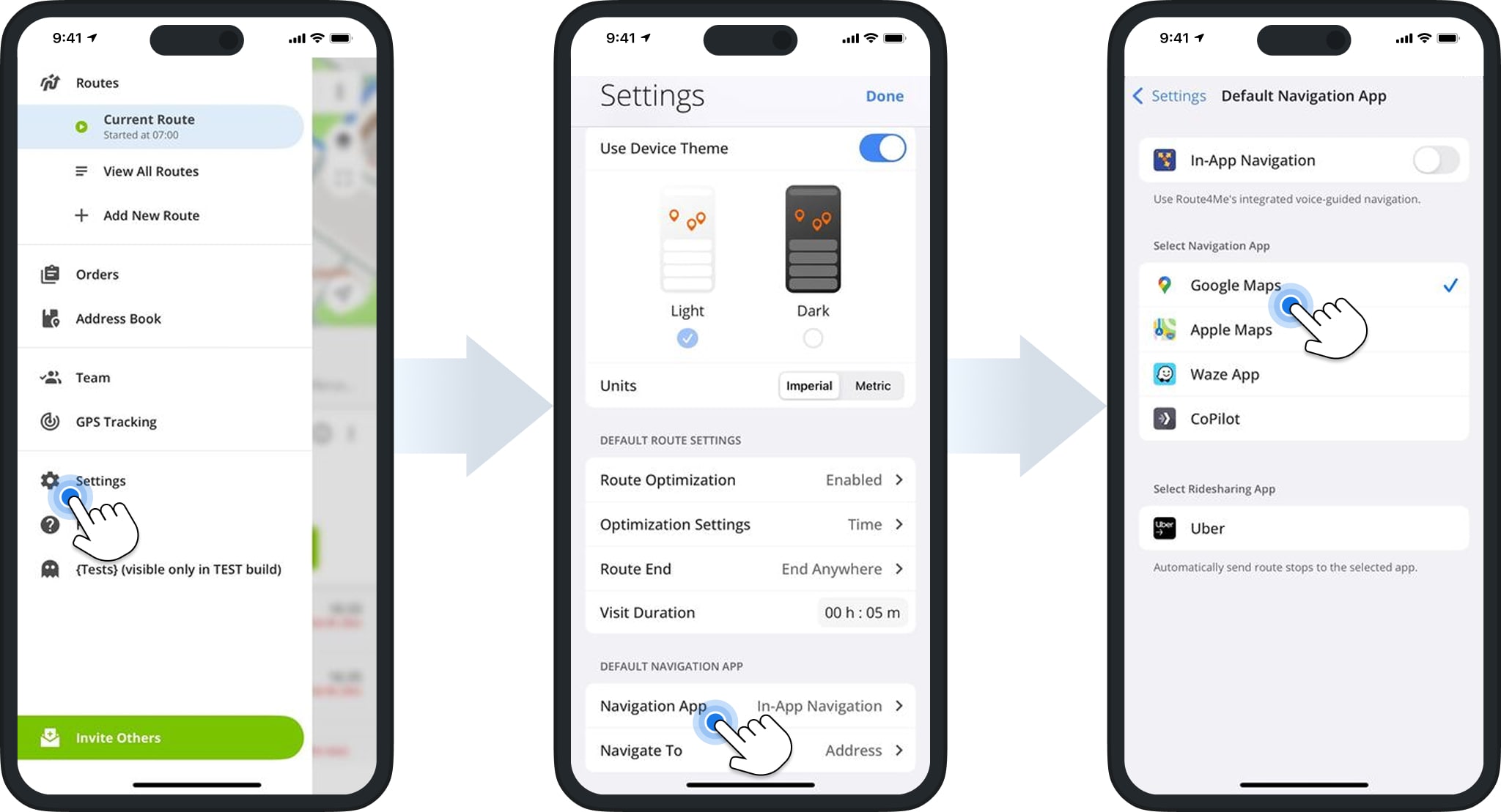
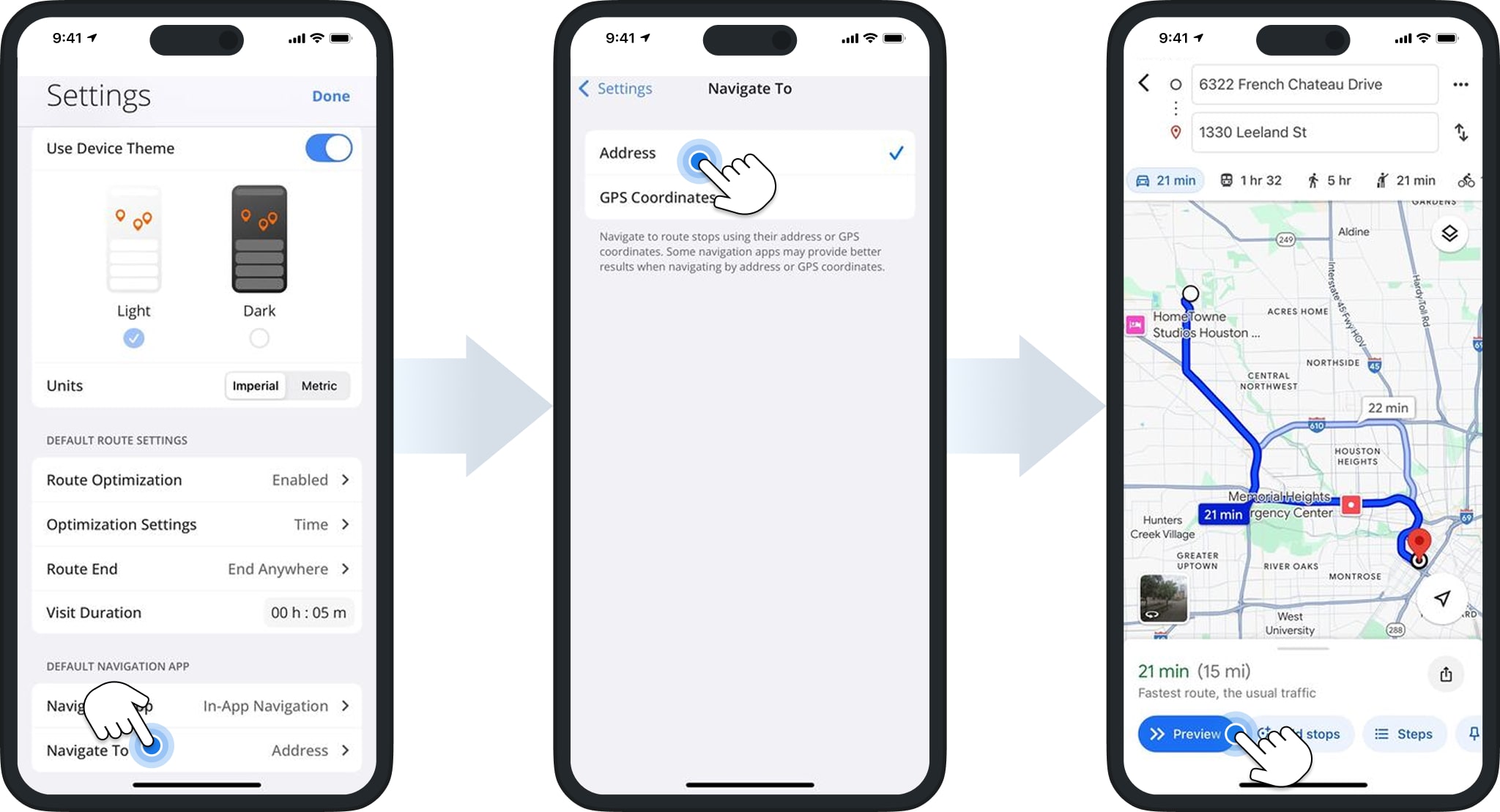
Once selected, return to the Settings screen and tap “Navigate To“. Choose whether you want to send addresses or GPS coordinates to the Google Maps app for navigation.
Route4Me will automatically transfer your choice to Google Maps. You can then preview your route and begin navigation.
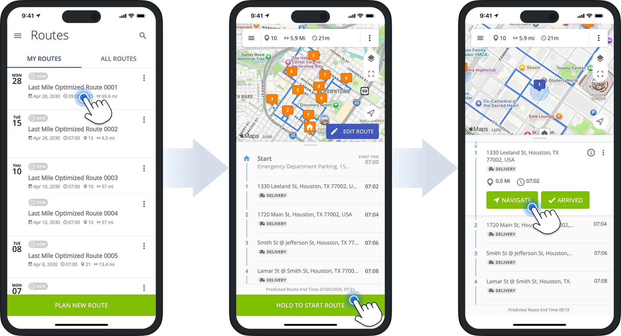
To begin navigation, tap the route. Then, tap “Hold To Start Route” followed by “Navigate” to send a destination to Google Maps.
Google Maps Directions For Driving, Walking, and Bicycling
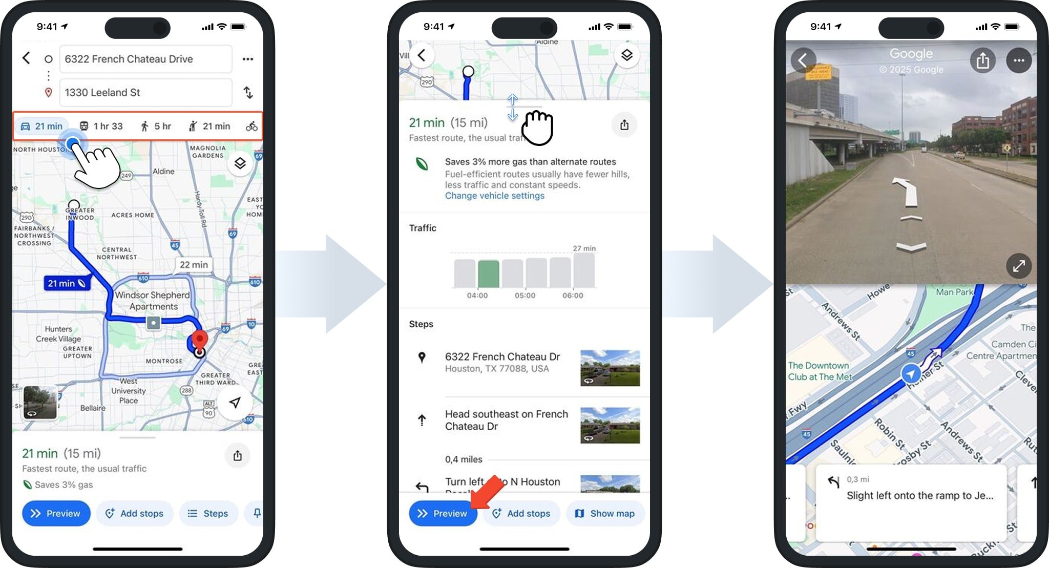
Once you’ve sent a route destination to the Google Maps app, you can use it to navigate to the stop. Begin by specifying the travel mode for the route: driving, walking, public transportation, cycling, or ride share.
Slide the screen up to view a detailed overview of the route based on your specified travel mode. To view a preview of the route on a map, click “Preview“.
Customize Google Maps Settings – Satellite View, 3D Map, And Other Map Details
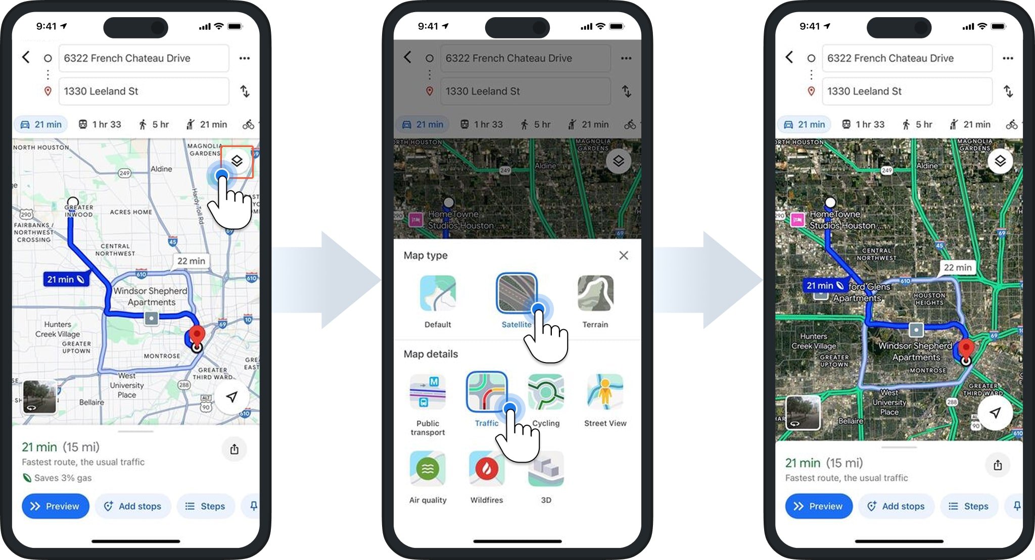
As you navigate to a destination, you can choose your preferred map view. Click the Map Icon to open the Map Type and Details menu. Then, select one or more thumbnails to adjust the map layout.
Google Maps will automatically update your map settings to reflect your selections.
Compare Route4Me Route Planner To Google Maps Route Planner
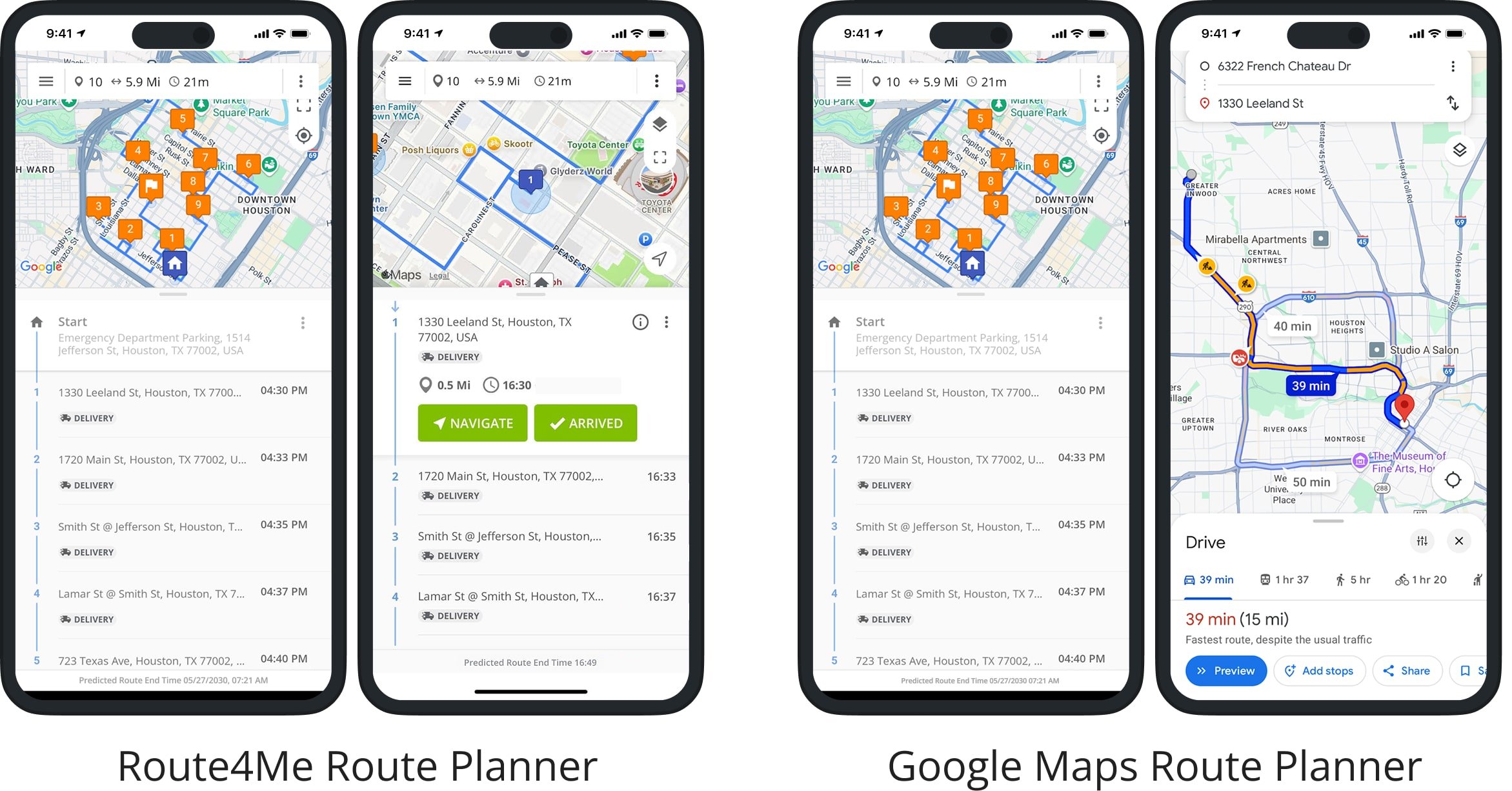
So, how does Google Maps compare to the Route4Me Route Planner app? In short, Google Maps lets you manually plan routes with up to 10 stops, but it doesn’t automatically optimize the sequence or support business-specific routing needs.
Our multi-stop route planner helps you optimize profitable, cost-efficient last mile routes by considering various business rules and customer needs. This makes Route4Me ideal for logistics-heavy businesses aiming to streamline deliveries, improve supply chains, and boost customer satisfaction. Plus, our mobile app lets you collect electronic proof of delivery, communicate with your team, and much more.
While Google Maps is great for basic navigation and casual multi-stop trips, it lacks the automation and commercial tools Route4Me provides. For businesses needing efficient last mile delivery or fleet coordination, Route4Me is the better fit.
| Feature | Google Maps | Route4Me | |
|---|---|---|---|
| Add Addresses and Import Route Data | |||
| Add Addresses to Routes Manually | |||
| Select Addresses from Device Contacts | |||
| Import Files with Addresses and Route Data | |||
| Google Drive Route File Import (CSV & XLS) | |||
| Dropbox Route File Import (CSV & XLS) | |||
| Upload Route Files from Device (CSV & XLS) | |||
| Use Current Location Address | |||
| Plan Multi-Stop Routes | |||
| Plan Multi-Stop Routes (Map and Manually Sequence Multi-Stop Routes) | |||
| Unlimited Route Planning | |||
| Unlimited Route Addresses | |||
| Schedule Routes | |||
| Dynamic Route Start Time | |||
| Optimize and Sequence Multi-Stop Routes | |||
| Optimize Routes (Map and Automatically Sequence Multi-Stop Routes) | |||
| Unlimited Route Optimizations | |||
| Unlimited Stops Sequencing | |||
| Round Trip Route Optimization | |||
| Lock Last Destination Route Optimization | |||
| End Anywhere Route Optimization | |||
| Disable Route Optimization and End Anywhere | |||
| Disable Route Optimization and Round Trip | |||
| Default Route Optimization Settings Profile | |||
| Route Directions Optimization | |||
| Shortest Time Route Directions Optimization | |||
| Shortest Time with Current Traffic Directions Optimization | |||
| Stops Management | |||
| Insert Stops into Planned Routes | |||
| Change Route Stops Sequence | |||
| Edit Route Stops Addresses and Information | |||
| Route Stops Service Times | |||
| Route Stops Custom Data | |||
| Open Route Stops on the Map | |||
| Delete Route Stops | |||
| Route Progress Tracking | |||
| Start and End Routes | |||
| Arrived Stop Status | |||
| Done Stop Status | |||
| Proof of Delivery, Field Service, Field Marketing, Field Sales Management | |||
| Add Text Notes | |||
| Image Attachment | |||
| Photo Attachment | |||
| Signature Capture and Attachment | |||
| Video Attachment | |||
| Audio Recording Attachment | |||
| Scan Barcodes | |||
| Navigation and Route Directions | |||
| Integrated Voice-Guided Navigation | |||
| Turn-By-Turn Route Directions | |||
| Single Stop Route Navigation | |||
| Continuous Route Navigation | |||
| Navigation by Address | |||
| Navigation by GPS Coordinates (Latitude and Longitude) | |||
| Refresh Route Directions | |||
Compare Google Maps Route Planner To Other Route Planner Alternatives
To help you choose the right navigation tool, we’ve compared Google Maps with other route planner apps commonly used by enterprise businesses. Below, you’ll see how the leading driver apps stack up against Apple’s navigation features.
Apple Maps Route Planner vs Google Maps Route Planner
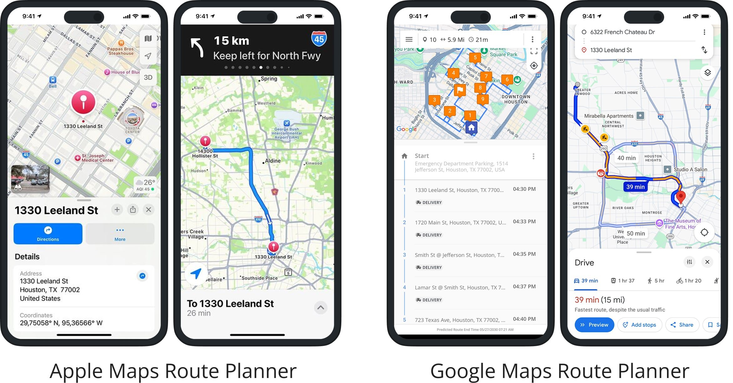
What about Apple Maps compared to Google Maps? In a nutshell, Apple Maps and Google Maps are similar in navigation capabilities, route planning, and overall user experience. Namely, both apps support real-time navigation, updated maps, location sharing, real-time ETAs, live traffic conditions, and real-time transit options for ride-sharing and public transport.
The biggest difference between Google Maps vs Apple Maps is that Apple Maps can plan a route between 2 locations only, while Google Maps can map and route up to 10 places. However, even though Google Maps can map multiple locations, it should not be used for business and commercial purposes.
Google Maps multiple stop route planner can’t automatically sequence addresses for the most optimal visitation order. Therefore, we recommend using a Google Maps alternative route planner app like Route4Me if you need to optimize multiple stops for the shortest travel times and route distances.
Waze GPS Navigation vs Google Maps Route Planner
How is Google Maps compared to the Waze GPS navigation app? Google Maps offers basic multi-stop routing, allowing you to manually add and reorder up to 10 stops. It’s more flexible than Waze, which only supports point-to-point navigation with no multi-stop planning at all.
However, neither app is designed for commercial or high-volume use. They lack key features like route optimization, bulk address input, driver assignment, and time window management, essential tools for delivery, field service, or enterprise operations.
If you need to plan efficient routes with multiple stops or manage a fleet, Google Maps and Waze fall short. A dedicated route planning app is the better choice for business needs, offering automation and features tailored for commercial use.
Get Circuit Route Planner vs Google Maps Route Planner
What is the difference between Google Maps vs Get Circuit route planner app? The main difference: the Circuit Route Planner app optimizes multi-stop delivery routes, while Google Maps is designed for basic navigation and single or manually arranged multi-stop trips.
Circuit is built for couriers and delivery businesses, allowing users to schedule deliveries, optimize routes, navigate, and collect electronic signatures. It also integrates with navigation apps like TomTom Go, Apple Maps, Google Maps, and Waze.
Google Maps lacks advanced route optimization and business-focused features, making it better suited for everyday users rather than delivery or field service operations.
Badger Mapping Route Planner vs Google Maps Route Planner
What about Apple Maps and Badger Mapping? Badger Maps is a sales and route optimization app for multi-stop routes, helping field teams map addresses and reduce travel time. It also supports customer management features and works with Apple Maps, Google Maps, and Waze for navigation.
Google Maps is better for everyday use, such as commuting or finding nearby places, but it lacks built-in route optimization and customer management tools. It’s not designed for sales reps or territory-based routing. Neither app supports full offline use, both requiring an internet connection for route planning and updates.
Routific Delivery Route Planning App vs Google Maps Route Planner
Routific offers delivery route planning, driver tracking, and proof of delivery via its web-based platform and mobile apps, with features tailored for logistics teams. A paid subscription is required.
Google Maps is free and works independently as a navigation tool, but it doesn’t support advanced route optimization or delivery management features found in Routific.
Onfleet Driver App vs Google Maps Route Planner
Onfleet is last mile delivery software where routes are created and dispatched through a web dashboard, then sent to drivers via the mobile app. Drivers cannot plan or adjust routes on their own within the app.
Google Maps allows users to plan and navigate their own routes without needing a connected web platform, but it lacks business tools like dispatching, tracking, or proof of delivery.
Upper Route Planner vs Google Maps Route Planner
Upper Route Planner is built for delivery professionals, optimizing multi-stop routes and providing navigation through its mobile app.
Google Maps is designed for general use and does not offer route optimization. It’s better suited for single or short multi-stop trips rather than commercial delivery planning.
Visit Route4Me's Marketplace to Check out Associated Modules:
- Operations
Advanced Team Management Add-On
Last Updated:
About author: Daniel Archer
With a background in pedagogy and writing instruction, Daniel is a former tenured English Instructor who, after nearly 20 years of teaching, transitioned into content strategy and leading writing teams for global brands. Now, as Technical Documentation Manager at Route4Me, he translates complex logistics technology into clear, accessible content that empowers users.