Route4Me Fleet Management and GPS Vehicle Tracking Software Frequently Asked Questions
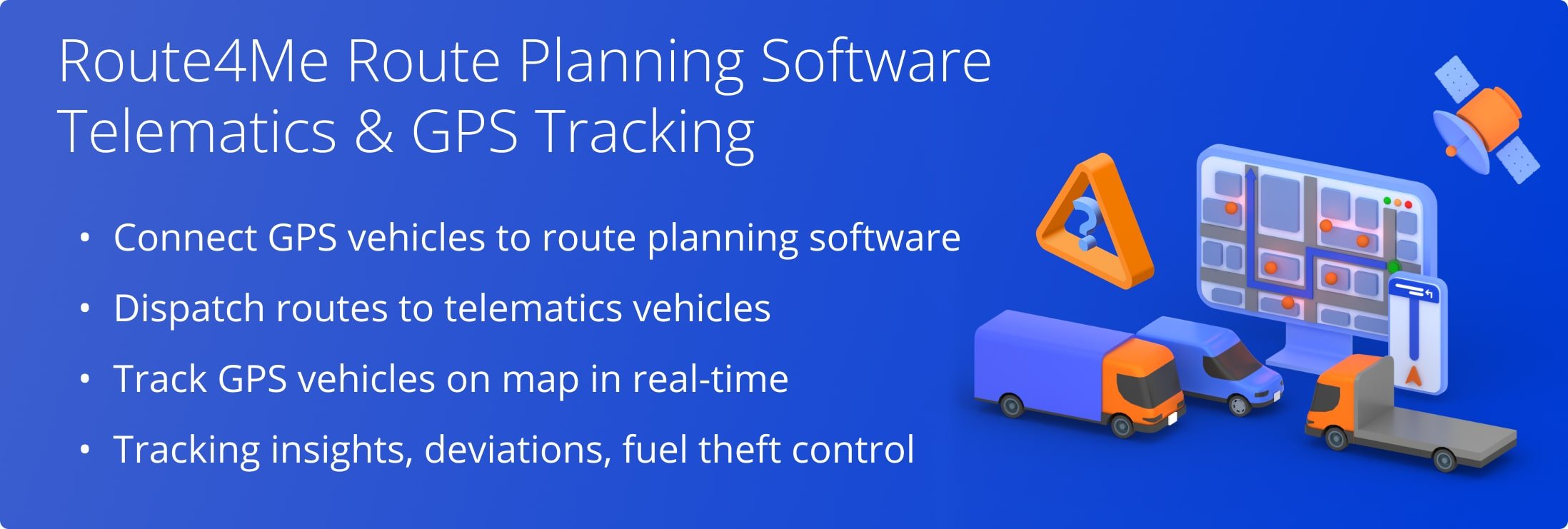
With Route4Me’s Fleet Management Software, you can easily create and manage a fleet of cars, vans, trucks, trailers, semis, heavy equipment, and any other vehicles. Specifically, you can customize the parameters of your vehicle with unique capacities, dimensions, weight, etc. Then, you can dispatch planned and scheduled routes to your fleet’s GPS vehicles for navigation. Furthermore, you can track your entire GPS fleet on the map in real-time. Additionally, you can track route deviations, fuel theft, vehicle performance and KPIs, and more.
Yes, with Route4Me, you can easily check the live GPS location of your vehicles and drivers on a tracking map. Furthermore, Route4Me’s vehicle tracking technologies also allow you to see the GPS breadcrumbs and detailed GPS tracking history of your route vehicles and drivers for any time period.
Route4Me’s Telematics Gateway allows you to integrate your Route4Me route planning software with almost all Telematics Vendors in the market. Once integrated, the data from your telematics devices, GPS trackers, smartphone apps, and other tracking hardware will be automatically sent to your Route4Me account. Route4Me will instantly process raw telematics data and display your drivers and vehicles on the map in real-time as they progress on their routes.
If you don’t have a telematics vendor and you don’t want to invest into a new GPS tracking system, GPS trackers, tracking devices, etc., you can use Route4Me’s Route Planning Apps that are free to download. Route4Me’s iOS Route Planner and Android Route Planner apps can be installed on your drivers’ smartphones and used as trackers.
Once the driver starts their route on the Route4Me mobile app, you will be able to see their live GPS location on the tracking map. In this way, you can plan routes, dispatch routes to drivers, and then track your vehicles and drivers in real-time within the same ecosystem.
If you liked this request for proposal (RFP) post about Route4Me’s live vehicle GPS location tracking, check out more Q&As!
Yes, Route4Me supports multiple integrations with various telematics vehicle tracking devices and third-party vendors. Route4Me’s Telematics Gateway allows you to integrate your route planning solution with almost any telematics vendor available in the market (Geotab, Teletrac Navman, Verizon Connect, and many more).
Once a telematics connection is established, Route4Me will automatically connect to all associated telematics vehicles and import a profile of each vehicle into your Route4Me account. You can then manage the corresponding telematics vehicle profiles in the Route4Me Vehicle Editor. You can set up telematics connections with multiple vendors at the same time. Route4Me will automatically import data from each vendor and show the connection health status in real-time.
When you establish a connection with a telematics vendor, you can automatically import telematics data from on-board diagnostics (OBD) devices, location trackers, GPS trackers, and other tracking devices into your Route4Me account. Once telematics data is imported from tracking devices into Route4Me, you can instantly see your vehicles on the tracking map in real-time. Alternatively, you can dispatch Route4Me optimized routes to telematics devices.
In addition to using third-party telematics vehicle tracking devices, you can also use Route4Me’s Android Route Planner and iOS Route Planner apps as vehicle trackers. All you need to do is install the app on your smartphone and log in with your Route4Me account. Telematics data will be automatically transferred from the app to your Route4Me account, and you’ll be able to see your drivers and vehicles on a tracking map.
If you liked this request for proposal (RFP) post about Route4Me’s integration with telematics vendors and GPS tracking devices, check out more Q&As!
Yes, Route4Me allows you to detect route deviations by locating your drivers and vehicles and showing them on the route map in real-time.
With Route4Me, you can either create new vehicles or import telematics vehicles. Route4Me’s Telematics Gateway enables you to connect your preferred third-party telematics vendor to your Route4Me route planning software. Once the telematics connection is established, you can automatically import vehicle profiles from the vendor to the Route4Me account and then manage the vehicles using Route4Me’s Vehicle Editor. After that, you can create driver profiles using the Route4Me Team Member Editor.
To detect route deviations, first, dispatch the route that you want to track to the preferred drivers and vehicles:
To dispatch a route to a vehicle, assign the vehicle to the route that you want to track.
To dispatch a route a driver, assign the driver to the route that you want to track.
Once the assigned vehicles and drivers start their routes, you can track them on the live tracking map. You can see how vehicles and drivers move on the map in real-time and check if they are deviating or following their routes. Route4Me’s GPS Tracking technologies allow you not only to detect route deviations in real-time but also to see the route GPS tracking history for any available time period.
For more convenience and efficiency, you can use Route4Me’s Android Route Planner and iOS Route Planner apps as vehicle trackers, GPS trackers, or as any other telematics devices.
If you liked this request for proposal (RFP) post about Route4Me’s route deviations detection, check out more Q&As!
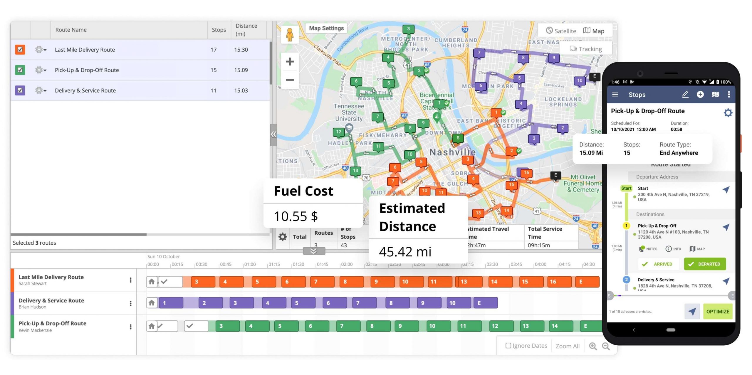
Yes, Route4Me’s route planning software allows you to track multiple fleet vehicles and drivers on the same route tracking map in real-time. You can import or add vehicles to your Route4Me account, dispatch routes to GPS vehicles and drivers, and then track them all on the same live tracking map.
Route4Me’s Telematics Gateway allows you to integrate route planning software with third-party telematics vendors and automatically import vehicles. Once you establish a telematics connection, you can automatically import vehicle profiles from the vendor into your Route4Me account and then manage your telematics vehicles using the Vehicle Editor. Alternatively, you can create vehicle profiles manually.
To see a vehicle on the tracking map, you need to dispatch a route located in the area on the map that you want to track to this vehicle. To dispatch a route to a vehicle, assign the preferred vehicle to the route. To dispatch a route to a driver, assign the driver to the given route.
Once the vehicle and/or driver are assigned to the route, you can open the given route in the Route4Me Route Editor or Routes Map and enable real-time vehicle and driver tracking. Route4Me will automatically show all active vehicles and drivers on the same map in real-time.
Route4Me’s route tracking map can show multiple live vehicles and drivers at the same time. Depending on the specified vehicle position refresh rate, you can see the live movement of each vehicle and driver on the map as they progress on their routes. You can click on any of the vehicles displayed on the map to see their details.
You don’t need expensive telematics devices to see multiple vehicles on the same tracking map. Route4Me’s Android Route Planner and iOS Route Planner mobile apps are free to download and can act as vehicle trackers, GPS trackers, and other telematics and tracking devices.
If you liked this request for proposal (RFP) post about tracking multiple vehicles and drivers on the map in real-time, check out more Q&As!
Yes, Route4Me allows you to record route vehicle mileage at the start and at the end of your routes. You can record the mileage of your vehicles using multiple methods:
- Edit vehicle profile and add vehicle mileage
- Add vehicle mileage to the member profile of the associated driver
- Record vehicle mileage using route custom data
You can also calculate the mileage at the start and end of each route and compare the before and after parameters. For example, if you have recorded the mileage at the start of the route, you can check the mileage at the end of the route and compare the difference with the total route distance.
Route4Me’s Telematics Gateway allows you to connect your route planning software to telematics vendors. When you establish a telematics connection with a telematics vendor, you can import various types of GPS route data into your Route4Me account. Depending on your telematics vendor, you may use different tracking devices, GPS trackers, on-board diagnostics (OBD), and other devices that can record vehicle mileage, driver behavior, etc.
Route vehicle mileage can also be recorded using Route4Me’s Mobile Route Planning Apps. You can record route mileage by adding notes using Route4Me’s Android Route Planner and iOS Route Planner apps. Furthermore, you can automatically synchronize all route mileage changes and dynamic route parameters with the Route4Me Web Platform in real-time.
If you liked this request for proposal (RFP) post about recording vehicle mileage at the route start and end, check out more Q&As!
Yes, Route4Me allows you to track all movements of your telematics vehicles, record tracking intelligence into the synced database, and view all the captured tracking data on interactive maps. Thus, you can see the exact GPS latitude and longitude coordinates, as well as the exact time when and where your vehicles traveled, where they stopped, where and how they are parked, and more.
Yes, Route4Me’s route optimization software provides multiple tools for detecting and preventing driver fraud. Route4Me can help you avoid a wide range of fraudulent activities – from fuel theft, speeding, and unauthorized idling to tempering with tracking devices. You can do so by using Route4Me’s geofencing features, GPS tracking solutions, analytics and reporting tools, the Rote4Me iOS Route Planner and Android Route Planner apps, and more.
Set Up Geofences to Detect Driver Fraud
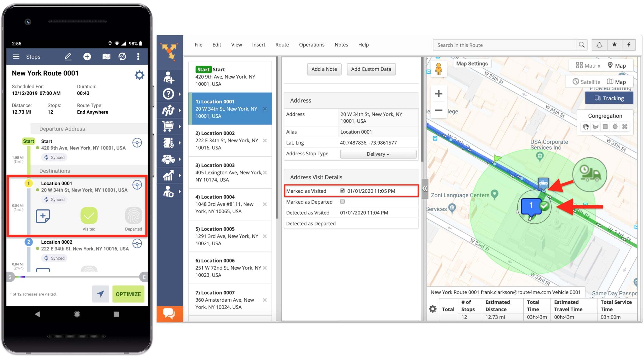
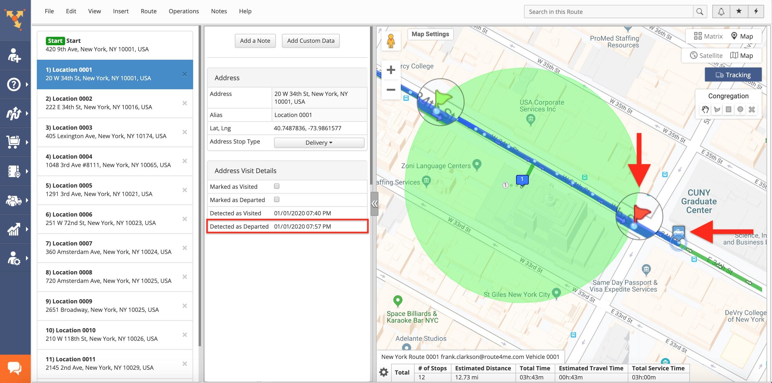
Route4Me’s geofences can be custom configured for various tracking and alerting purposes. For example, geofences can automatically detect and trigger alerts or create timestamps. Additionally, you can even configure your geofences to detect when your drivers are speeding.
For example, you can use geofences for detecting fraud by enabling the automatic geofence-generated timestamps. Namely, Route4Me can automatically generate “Detected as Visited” and “Detected as Departed” timestamps upon drivers’ entrance into and departure from a geofenced area.
Simultaneously, Route4Me’s Mandatory Actions enable you to require drivers to manually mark stops as “Visited” and “Departed” before moving on to the next stop. Then you will be able to compare the differences between the two timestamps and assess your drivers’ performance.
Furthermore, Route4Me enables you to detect and prevent driver idling. Particularly, Route4Me allows you to check where drivers enter geofences and how long they stay within each geofence.
Generally, Geofences are triggered by Route4Me’s route planner apps. Additionally, you can also integrate any telematics devices with Route4Me. The integrated telematics devices will also trigger geofences and detect drivers’ activity within geofences.
Furthermore, you can also set up geofences around depots and automatically record when drivers enter or exit the geofenced depot. By doing so, you will make sure drivers don’t use vehicles after working hours.
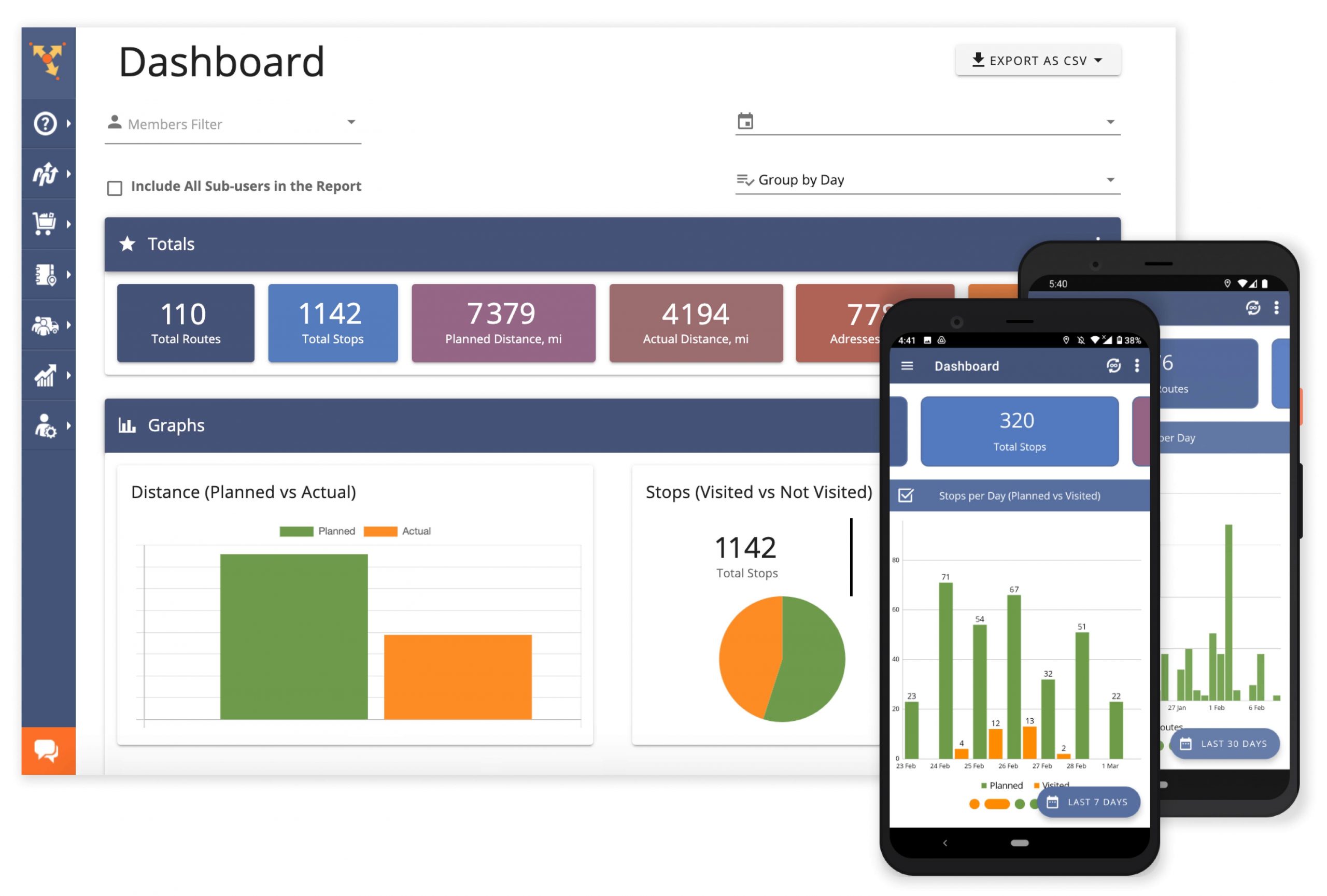
Planned vs. Actual Route Planning Metrics
On the same note, Route4Me’s analytics and reporting Dashboard helps you monitor your drivers’ historic and real-time progress while navigating routes. Mainly, the Dashboard provides detailed comparison graphs to highlight the difference between your planned route metrics and the actual route outcomes.
For example, you can audit the performance of your infrastructure and driver team through metrics such as Planned vs. Actual Route Distance, Planned vs. Actual Route Time, Planned vs. Visited Route Stops, etc. For instance, the Planned vs. Actual Route Distance report will help you identify whether drives actually drove the required miles, how many miles they didn’t complete, etc.
Prevent Driver Fraud With Live GPS Tracking and GPS Tracking History
Route4Me’s iOS Route Planner and Android Route Planner apps also help you to prevent driver fraud. The Route Planner apps provide multiple layers of GPS data security that enable you to prevent tampering with GPS trackers.
Route4Me’s driver tracking solutions collect GPS data from your drivers’ Route4Me Route Planner apps and/or telematics devices every second. Then, the system displays your vehicles’ location on the interactive map in near real-time.
![]()
Learn more about Route4Me’s Telematics Gateway and the ability to integrate your Route4Me route optimization software with any telematics vendor in today’s market.
![]()
With Route4Me’s live driver tracking features, you are able to detect and prevent unauthorized vehicle use, idling, and more.
In addition to real-time GPS tracking, Route4Me provides GPS tracking history tools. GPS tracking history gives you an overview of your completed routes in retrospective, in an animated video format.
Furthermore, Route4Me’s tracking solutions are capable of identifying any route deviation and detour in near real-time. This feature helps you make sure your drivers follow the planned routes. Thus, your company’s time and fuel will not be wasted by driving unauthorized alternate routes.
Fuel Consumption and Fuel Costs Analytics
To further support your efforts to prevent driver fraud and fuel theft, Route4Me offers you multiple tools for tracking the fuel consumption and fuel costs of each fleet vehicle. Moreover, Route4Me’s Fuel Consumption and Costs Analytics generate reports for each user so that you can identify fuel card fraud, fuel siphoning, etc.
Visit Route4Me's Marketplace to Check out Associated Modules:
- Operations
Custom Data Add-On
- Operations
Advanced Team Management Add-On